
The problem
Old Chattanooga had to live with the Tennessee River coming into town.
Chattanooga's geography gives the city its scenery, but it also created a brutal flood problem. Water draining out of a huge upper Tennessee River watershed reached Chattanooga and then had to squeeze through the mountain gorge below the city. During high flows, that bottleneck slowed the river and backed water into the valley. [3]
TVA says Chattanooga experienced serious flood damage in 1867, 1875, 1886, and 1917. By the time TVA was created in 1933, estimated direct annual flood damage around Chattanooga was about $1.7 million, before counting interrupted transportation, lost business, sanitation problems, and other indirect costs.[1]
The biggest recorded Chattanooga flood came in March 1867. The Tennessee River crested at just under 58 feet and inundated much of the city. It is hard to reconcile that with the controlled riverfront most of us know today until you look at the old flood map. [3]
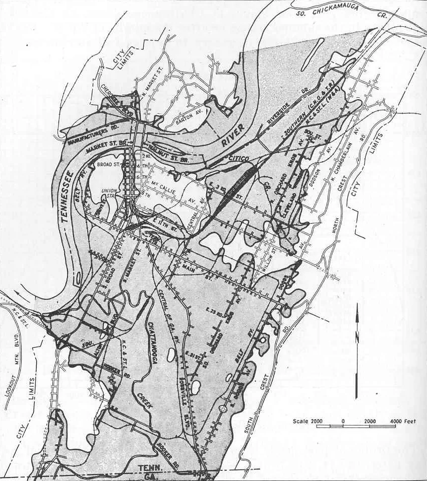
Before Chickamauga Reservoir
The river north of town was a much more variable landscape.
Before Chickamauga Dam closed its gates, there was no Chickamauga Reservoir stretching nearly 59 miles upstream. River level and shoreline changed much more with rainfall and seasonal flow. Floodplain land that is now under or beside the reservoir held farms, homes, roads, cemeteries, woods, and communities. [1][2]
Creating the reservoir required TVA to purchase more than 61,000 acres. More than 900 families were relocated, along with 24 cemeteries and 81 miles of roads. About 6,000 wooded acres had to be cleared. Those numbers are a reminder that "building a lake" meant remaking an inhabited landscape, not simply putting a concrete wall across an empty river.[1][6]
There is another wrinkle: pre-Chickamauga Chattanooga did not have a completely free-flowing river either. Hales Bar Dam had been operating downstream since 1913. It was the first main-stem multipurpose dam on the Tennessee River and had already altered navigation and river levels below Chattanooga before TVA began Chickamauga. [5]
So the cleanest way to think about the change is this: Chickamauga Dam transformed the river upstream of the city into a large managed reservoir, while TVA's broader chain of dams eventually turned the Tennessee into a connected stairway of navigable pools.
What changed most?The river stopped being something Chattanooga simply endured.It became something engineers could manage as a system.
Why TVA chose to build it
Flood control came first.
TVA is unusually explicit about this: flood control was the primary consideration in planning and constructing Chickamauga Dam. The project was authorized on December 31, 1935, and construction began in January 1936. [1]
But TVA was never supposed to be a one-purpose dam builder. Its unified river plan combined flood control with commercial navigation, hydroelectric generation, economic development, public health, and coordinated management of the Tennessee River watershed. [1][4]
Hold and move water through a coordinated reservoir system instead of letting high flows pile into Chattanooga.
Locks and managed pools helped turn the Tennessee into a reliable commercial transportation corridor.
Chickamauga became a hydroelectric facility within TVA's rapidly expanding regional power network.
Flood protection, power, navigation, and infrastructure made the Valley more practical for homes and industry.
Building the project
Four years of construction changed miles of river valley.
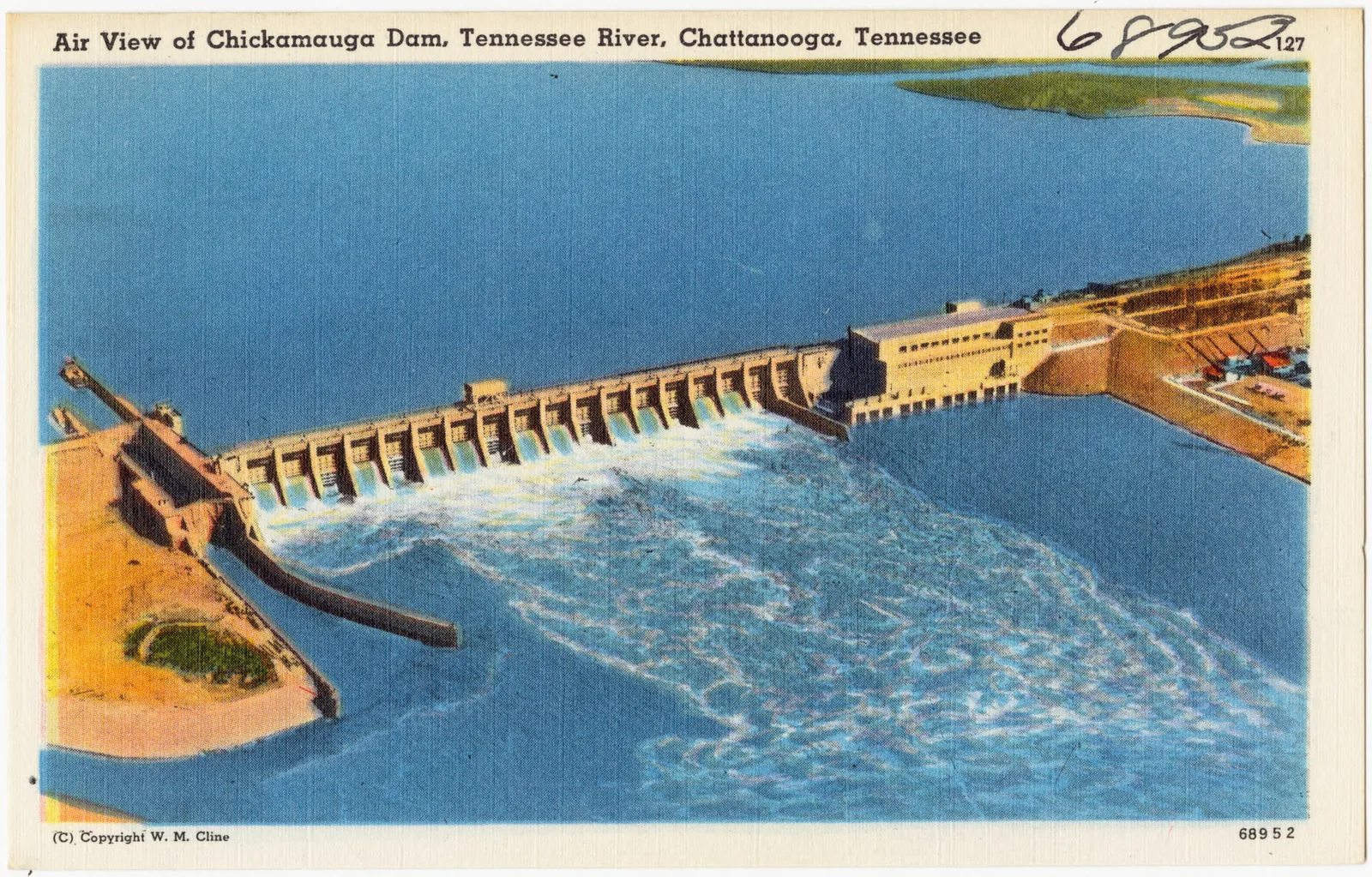
TVA selected the tip of Chickamauga Island for the dam after surveying possible sites. At peak construction, roughly 3,000 people were working on the project. The structure ultimately stretched about 5,800 feet across the river and stood 129 feet high. [1]
The dam closed in January 1940, allowing the reservoir to take shape. President Franklin D. Roosevelt formally dedicated Chickamauga Dam on September 2 of that year. The final hydroelectric generating unit was completed later, in 1952.[1]
The finished project was not just the visible concrete powerhouse and spillway. It included the reservoir, lock, transmission infrastructure, relocated transportation routes, land clearing, shoreline changes, and the human work of moving families and cemeteries out of the future pool.
The important correction
Chickamauga Dam did not solve flooding by itself.
It is tempting to tell the story as "Chattanooga flooded, TVA built Chickamauga Dam, problem solved." The real engineering is more interesting.
TVA manages the Tennessee as a system. Reservoirs far upstream on tributaries such as the Clinch, French Broad, Holston, Little Tennessee, Hiwassee, and other rivers can store enormous amounts of water before it ever reaches Chattanooga. TVA says that before the coordinated system existed, high flow would reach the Tennessee River Gorge, slow down, back up, and flood Chattanooga at least once a year. [3]
Chickamauga is a critical piece of that system, but the city's flood protection comes from reservoirs working together. TVA even uses flow at Chickamauga Dam as a key indicator for managing the upper Tennessee River system. [4]
The difference shows up dramatically in later floods. In 1973, Chattanooga reached nearly 37 feet. TVA estimates that without reservoir regulation, the river would have reached 52.4 feet.[3]
Before and after
What changed around Chattanooga?
High water regularly spilled into floodplains and developed areas. The upper river lacked today's 59-mile managed reservoir.
Chickamauga Reservoir created a much more stable navigation pool and permanently changed shorelines, access, and land use.
Chattanooga's downstream gorge created a natural bottleneck that made major floods especially destructive.
TVA now balances flood storage, navigation, power, water supply, water quality, and recreation across the river system.[4]
A different kind of river
The Tennessee became transportation infrastructure.
The old Tennessee River could move boats, but shoals, rapids, changing depths, floods, and seasonal conditions made dependable navigation difficult. Hales Bar was an early attempt to improve that situation below Chattanooga.[5]
TVA's lock-and-dam system took the idea much farther. Instead of treating each difficult stretch separately, the agency developed a connected series of controlled pools and locks. Commercial traffic could move through Chattanooga as part of a much larger inland navigation system.
That is one of the reasons the river today can feel almost lake-like in places. What looks natural at first glance is actually a highly managed piece of infrastructure.
The reservoir people know today
Chickamauga Lake is a side effect that became an identity of its own.
TVA lists Chickamauga Reservoir at roughly 59 miles long, extending upstream from the dam to Watts Bar Dam. Today it is tied to boating, fishing, swimming, waterfront neighborhoods, parks, marinas, wildlife habitat, and recreation around the Chattanooga region. [2]
None of that was the primary reason the project was authorized. Recreation was one benefit of a much larger effort to control floods, maintain navigation, and generate power. Over time, though, the reservoir became so normal that it is easy to forget how recently that landscape was created.
Quick answers
Chickamauga Dam FAQ
Why did TVA build Chickamauga Dam?
Flood control was the primary consideration. Navigation, hydroelectric power, economic development, and coordinated river management were also central parts of TVA's unified plan. [1]
When did Chickamauga Dam open?
Construction began in January 1936. The dam closed in January 1940 and President Franklin D. Roosevelt dedicated it on September 2, 1940. [1]
Was Chattanooga already behind a dam before 1940?
The river below Chattanooga had already been altered by Hales Bar Dam, which began operating in 1913. Chickamauga transformed the river upstream by creating the reservoir north of the city. [5]
How large was Chattanooga's worst flood?
The March 1867 flood crested at nearly 58 feet in Chattanooga and remains the city's largest flood on record. [3]
The takeaway
Modern Chattanooga is built around a river that no longer behaves like the old one.
The Tennessee River is still powerful enough to flood, and TVA still has to constantly balance water moving through the watershed. The difference is that Chattanooga now sits inside an engineered river system instead of simply waiting to see how high the next crest will rise.
Chickamauga Dam is the most visible local piece of that story. The larger change came from treating hundreds of miles of rivers, tributaries, reservoirs, locks, and dams as one coordinated machine.
The lake, the lock, the power plant, and the parks are what we see today. Flood control is why the project started.